")
")
")
")
")
")
")
|
195 km |
Hills |
Messinian Salinity Crisis |
The stage from Le Bourg d’Oisans to Saint Etienne brings the peloton from the foreland of the Alps to the crystalline massif of the Central Massif, and thereby crosses the Rhône Valley. The valley of today will not particularly impress the rides, but that would have been quite different in the geological past! The Rhône valley lies in the foreland of the Alps and is mostly fed by water and sediment that comes mostly from the Alps, but also from the Central Massif. At first sight, this makes the Rhône a river like many, draining a mountain range and transporting its sediment to the nearest sea, in this 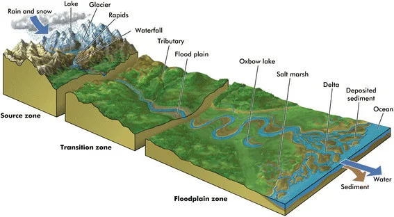 case the Mediterranean Sea. But the Rhône underwent a spectacular history in the geologically speaking, recent past, of the last 6 million years. And this led to a subsurface that is pretty popular among wine-lovers!
The ideal profile of a river
Rivers like the Rhône typically originate as a wide network of streams in mountain ranges that one by one merge to eventually form a large river, heading for the sea. And in the process, rivers attempt at developing an ideal profile that looks a bit like a giant ski-jump: close to the source, rivers flow steeply down-hill and cut into the underlying bedrock. But as the river approaches its mouth, the bedding becomes shallower. Down-stream, rivers flow slower, become wider and transfer from mountain streams, to braided rivers full of pebbles, to meandering rivers that slowly progress through flat lands, to eventually reach the delta (Figure). If the river bed is not steep enough, a river will cut down to steepen the profile. If a river bed is too steep, the river will deposit sediments to make it  shallower. Changes in sea level at the river mouth thus have an important effect on an entire river: if sea level rises, the mouth of the river will migrate inland and the old bedding will become too steep: the river will respond by depositing sand and clay on land. But if sea level drops, the river will respond by cutting down along its length.
The Messinian Salinity Crisis - The desiccation of the Mediterranean Sea
The ideal profile of the Rhône river is influenced by the sea level changes of the Mediterranean Sea. The Mediterranean Sea is in many places underlain by oceanic crust, and in those places, water depths reach 4-5 km or more. But the connection to the Atlantic ocean is a very narrow and shallow bottleneck: the Straits of  Gibraltar. And approximately 5 and a half million years ago, during the Messinian period, tectonic motions between Morocco and Spain closed the connection of the Mediterranean Sea to the world’s oceans.
Because the rivers that feed water to the Mediterranean Sea, like the Rhône and the Nile, are unable to supply enough water to balance the water lost by evaporation, sea level in the Mediterranean Sea started to drop. This process is currently active in the Dead Sea, where today’s sea level is 427 m below global sea level (!!), and which in the process became incredibly salty. Sea level of the Mediterranean Sea during the Messinian thus dropped and dropped, and
[2/3] Then the Mediterranean was evaporated, depositing a layer of salt up to 3 km in thickness. When the Atlantic waters found a new way through the Strait of Gibraltar, the Med underwent the largest flooding event ever recorded. pic.twitter.com/2it5qUAZtm
— Daniel García-Castellanos (@danigeos) February 3, 2020
thick packages of gypsum and rock salt were deposited in this period. This period is known as the Messinian Salinity Crisis which are visible in the hills,some of which have been uplifted by tectonic processes and are now visible in countries surrounding the Mediterranean Sea like Greece, Italy, and Spain (see photo). Many geologists believe that the water level of the Mediterranean Sea dropped a kilometer or more (see theTwitter video’s embedded in this article).
The Grand Canyon of the Rhône
The Rhône and its tributaries, like the Ardèche, responded to this extreme sea level drop by cutting down kind of a ‘Grand Canyon’ that became more than 500 m deep. Geologically speaking, this occurred very fast, within about a hundred thousand years. Approximately 5.3 million years ago, the modern Gibraltar Straits opened and refilled the Mediterranean Sea with sea water (see the Twitter videos). The deeply incised Rhône canyon was filled with sea water, and in the millions of years that followed, this canyon was filled with gravel, rich in quartz from the Alps and the Central Massif, that was carried by the Rhône River. These quartz-rich gravels are fertile ground for grapes such as the Châteauneuf-du-Pape! If the Tour de France would have been organized during the Messinian salinity crisis, today’s stage would have been considerably more mountainous than today’s stage!

I am a geologist and I study plate tectonics and the driving mechanisms in the Earth’s mantle, mountain building processes, and the geography of the geological past. I enjoy geological fieldworks all over the world, and translating the results to science and a broad public.
Check the TdF-team for more info.
Douwe van Hinsbergen